 Photo: Hüsna Kefelioğlu / Pexels / Pexels License
France — Pyrenees
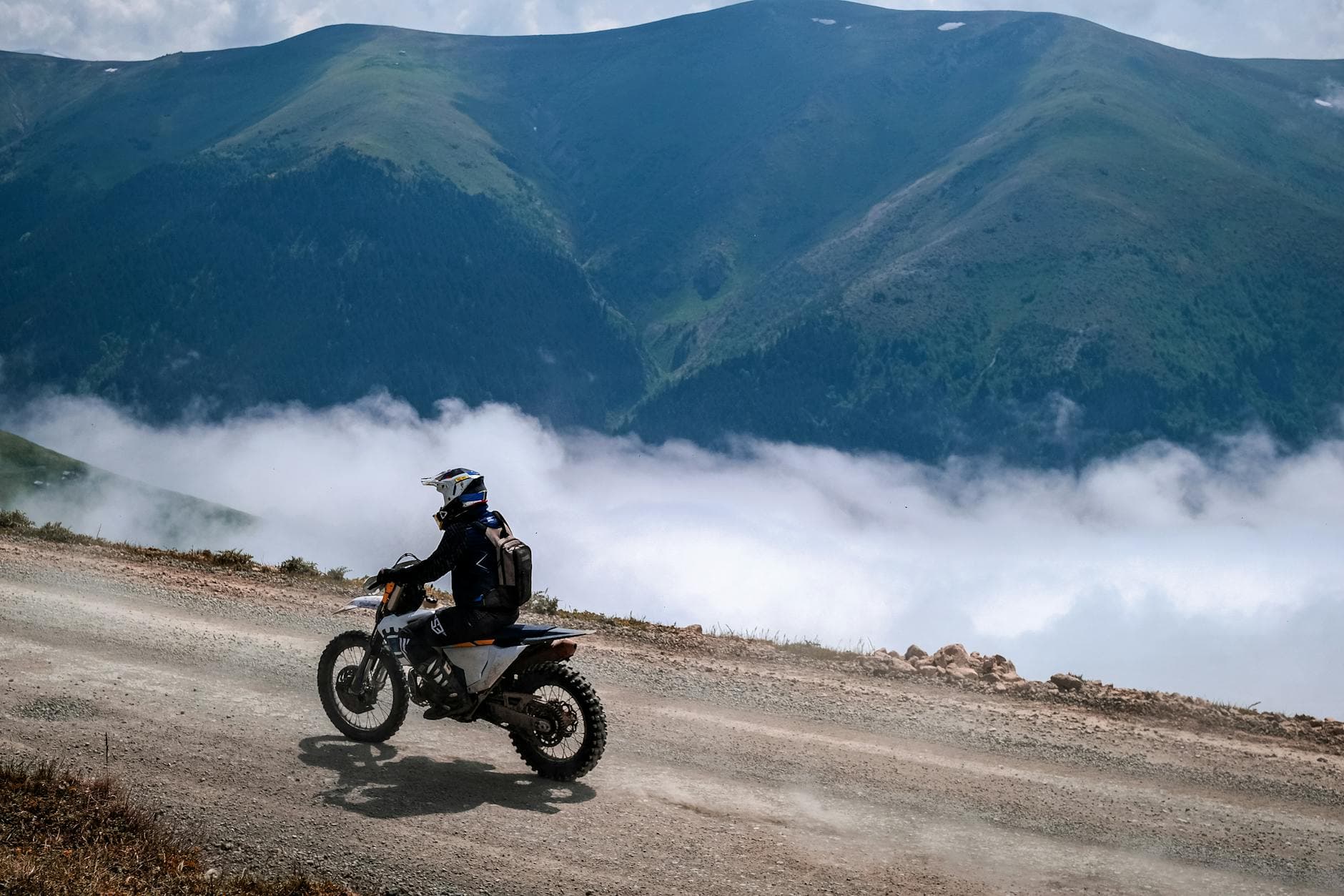
The Pyrenees — Col du Tourmalet & the High Mountain Passes
Key highlights
- Col du Tourmalet (2,115m) — highest paved pass in the French Pyrenees, Tour de France legend since 1910
- Col d'Aubisque (1,709m) — narrow corniche section cut into a cliff face, spectacular exposure
- Col d'Aspin (1,489m) — a gentler connecting pass through mountain pasture, good sightlines
- Cirque de Gavarnie — UNESCO World Heritage valley cirque with Europe's highest waterfall
- D918 thread — the road that connects Laruns, Argelès-Gazost, and Lourdes in a single high route
The Pyrenees have been a Tour de France fixture since the race first crossed them in 1910, when riders walked their bikes up the Tourmalet in the dark. A century and more later, the mountain roads are paved, well-marked, and carry the particular atmosphere of roads that have meant something to people — cyclists, pilgrims, smugglers, soldiers — for a very long time. A 280km loop based out of Lourdes or Tarbes covers the Tourmalet, the Aubisque, the Aspin, and the valley circuits that connect them. It is the most concentrated high-pass riding in France.
Col du Tourmalet
The Tourmalet (2,115m) is the highest paved pass in the French Pyrenees and the most frequently used col in Tour de France history. The eastern ascent from Sainte-Marie-de-Campan climbs 17 kilometres at an average gradient of 7.4%, with the upper section tightening to switchbacks as the road clears the treeline and approaches the bare mountain above La Mongie ski station. The western descent toward Luz-Saint-Sauveur is steeper and more exposed — 19km at an average of 7.3% — and delivers the better views on a clear morning, with the Pic du Midi observatory visible on the ridge to the north-east.
The summit has a statue of a cyclist, a snack bar, and in summer a constant rotation of motorcycles, cycling groups, and support vehicles. Early starts avoid the worst of the congestion. The road surface on both sides is good — resurfaced regularly because the tourist and cycling economy of the surrounding towns depends on it staying open and accessible.
Col d'Aubisque
The Col d'Aubisque (1,709m) is a different character from the Tourmalet. The western approach from Laruns climbs through the beech forests of the Ossau valley — a steady, sustained ascent with good camber through the wooded lower section and progressively more open views as the road climbs above the treeline. The summit is broad and grassy, with the Pyrenees ridge visible to the south in Spain on clear days.
The section that makes the Aubisque famous is the corniche east of the summit: a narrow road cut into the cliff face with no barrier on the drop side and a rock wall on the other. At points the road is barely wide enough for two cars — on a motorcycle it is fine, and the exposure is the point. The corniche runs for several kilometres before the descent to Argelès-Gazost, delivering a sustained stretch of genuinely dramatic alpine riding that the Tourmalet, for all its scale, does not match for immediate atmosphere.
Col d'Aspin
The Col d'Aspin (1,489m) connects Sainte-Marie-de-Campan in the east to Arreau and the Aure valley in the west. It is the gentlest of the three main passes on this loop — smoother gradient, wider road, open views over mountain pasture from the summit — and works well as either an introduction to the Pyrenees or a closing section after the more demanding Tourmalet and Aubisque. The descent into Arreau through the lower meadows is one of the more pleasant low-speed sections in the region.
Cirque de Gavarnie
The Cirque de Gavarnie is a UNESCO World Heritage site at the end of a valley south of Luz-Saint-Sauveur. The road from Luz is a straight, fast run up the valley floor to the cirque car park at 1,380 metres, from which the cirque itself (a natural horseshoe of rock walls rising to 3,000m, with Europe's highest waterfall at 422m) is a 45-minute walk. It is a diversion rather than a riding challenge, but the scale of the amphitheatre — visible from the car park — justifies the stop.
The D921 from Luz to the cirque also carries riders toward the Port de Gavarnie and the Spanish border at 2,270 metres if you want a cross-border extension. The Spanish side drops into the Ordesa y Monte Perdido National Park. The border crossing is unmarked and unguarded; the road quality changes noticeably.
Practical Matters
Fuel towns are Lourdes, Tarbes, Argelès-Gazost, and Luz-Saint-Sauveur. Above Luz there is no fuel until the Spanish side or the return to Lourdes. Fill up in Luz before heading toward Gavarnie or the Tourmalet. The Tourmalet closes in winter — typically from mid-November to mid-May depending on snowfall — and can close temporarily in summer during the Tour de France itself, when the road becomes a race route for a day. Check the Hautes-Pyrénées department website for current closure information before riding the summit roads out of season.
The D918 road that links Laruns, the Aubisque, Argelès-Gazost, and Lourdes is the spine of the western Pyrenees riding circuit and carries significant motorcycle traffic from May through September. French gendarmerie are present on the main cols, particularly after accidents on the descent roads. The Aubisque corniche section has a genuine record of incidents when ridden quickly in the wrong direction — approaching from the west (Laruns side) and descending east gives you the drop on the outside, which is psychologically more demanding but technically safer than the alternative.
When to Go
Mid-May to October. The Tourmalet and Aubisque typically open in mid-May after snowploughs have cleared the summit sections; the exact date varies by winter snowfall. June and September are the recommended months — fewer tourist vehicles, better weather windows, and accommodation available without six-month advance booking. July and August are fine for riding but Lourdes (which handles several million pilgrims per year) makes a poor base in peak season. Tarbes, 20km north, is quieter and better-positioned for an early start on the passes.
Where to Stay
Luz-Saint-Sauveur, Argelès-Gazost, Cauterets, and Arreau all have accommodation suited to motorcycle touring, with secure parking and proximity to the main passes. Browse the full list of Pyrenees biker-friendly accommodation in our directory. The Pyrenees loop extends naturally into northern Spain — the Val d'Aran and the Spanish Pyrenees are accessible via the Port de la Bonaigua (2,072m) — for riders with a week rather than a long weekend.